 |
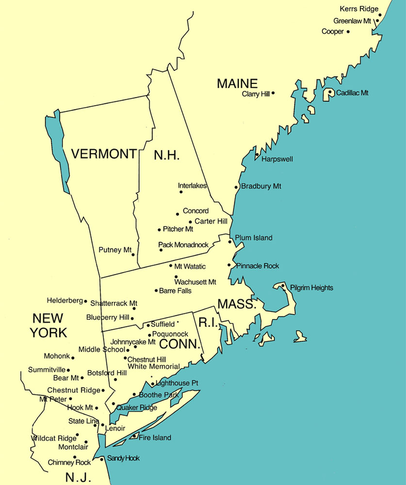
Selected Hawk Watch Sites
|
|
|
Selected Hawk Watch Sites
|
| Connecticut: Lighthouse Point; Quaker Ridge; Chestnut Hill |
| Massachusetts: Blueberry Hill; Mount Watatic; Wachusett Mountain |
| New Hampshire: Little Round Top; Pack Monadnock |
| New Jersey: Chimney Rock; Montclair; Wildcat Ridge |
| New York: Chestnut Ridge; Fire Island; Hook Mountain; Mount Peter |
| Blueberry Hill, West Granville
MA. From east or west take Exit 3, Mass Pike and turn south
(right) on Rtes 10 & 202. Go into Westfield and take right
(west) on Rte 20 for 1 mile. At blinking yellow light take left on
Lloyds Hill Road. At end take right, then immediate left on Broadway. At
end take right on Granville Road, bearing right after crossing bridge to
keep on this road. At 1/2 mile keep right at fork. Go 3-4 miles to end and
take right on Rte 57 west. Go 4 miles and take right on North Lane, Go 1.2
miles and park along road just past chain across trail on right. Follow
trail to top (easy 5 minute walk). From north or south take exit 14
off Rte 91 to Mass Pike exit 4, then go west to Westfield exit
3. Top |
|
Chestnut Ridge Hawk Watch Bedford, New York:
Take I-684 to exit 4 (Bedford-Mt Kisco-Route
172) and turn off the ramp toward Mount Kisco. (Left if coming from the
South, right if coming from the North.) Drive
about 100 yards and take first left on to Chestnut Ridge Road.
Take Chestnut Ridge Road for about 1.5 miles
and look for the entrance on the Right, the sign for the Nature
Conservancy's Butler Sanctuary and go across the bridge to the parking lot.
The Hawk Watch is up the hill to the left (see sign
just inside the fence).
|
| NJAMP Chimney Rock, Martinsville NJ. The
Chimney Rock hawk watch is located on the First Watchung Ridge in
Martinsville, New Jersey. Chimney Rock is most easily accessible from
Interstate 287. From the north or south take 287 to the exit for Route 22
east. Follow Route 22 east for approximately 1 mile. Turn right onto the
jug handle at Vosseler Avenue. Turn left onto Vosseler Avenue and cross
Route 22. Proceed uphill until you reach the peak (about .6 miles). Look
for Miller Lane on your left. Turn left onto Miller Lane. Drive about .5
miles down Miller Lane to the parking lot for the hawk watch. NOTE:
Miller Lane is narrow and mostly gravel, with a number of private
residences along it. Please drive slowly and yield to oncoming cars. The
trail to the watch begins at the far end of the parking
lot. Top |
| Fire Island
Raptor Enumerators, Robert Moses
State Park, New York: The hawk watch is on a
barrier beach, off the south shore of Long Island, NY. We're about midway
along Long Island, slightly west of due south from New Haven CT. Driving
directions: Proceed south on Robert Moses Parkway, over the bridge
to Robert Moses State Park. From the water tower circle (check for
PG), proceed East to parking lot #5. From the NE corner of the lot,
walk east toward the lighthouse. We watch from the platform near the road
barriers. Top |
| Hook
Mountain, Hook
Mountain State Park, Upper Nyack, New York: The
hawk watch is at the top of Hook Mountain, 730 feet above sea level,
overlooking the Hudson River, just north of the Tappan Zee bridge.
Driving
directions: From I-287/I-87, take Exit 11 (Nyack) Proceed
to Route 9W. Turn left onto 9W. Continue past the traffic
light, past Christian Herald Road to the top of the hill. At about
1.8 miles from the turn onto 9W look for the unpaved parking pulloff on
the right. (Limited parking, rough surface.) Walk north on east side
of the road to triple yellow mark. Proceed up the yellow trail,
Paddy's Path to the top of the mountain, about 1/2 mile hike up with some
steep sections. Alternate
directions are from the Golf Course at Rockland Lake State
Park. Top |
| Lighthouse Point Park,
New Haven, Connecticut:
To reach the park, if
heading north on Route
95, take Exit
50 (Woodward Avenue, Lighthouse Point). Turn right
onto Townshend Avenue
and proceed about 2.1 miles to
Lighthouse Road. Turn right onto Lighthouse Road,
which leads into the park, and keep to your left, going towards the
bathhouse. Hawk watching is generally done from the parking lot just
east of the large field before the bathhouse. If heading south on Route 95, take Exit 51 (U.S. 1, Frontage Road,
Lighthouse Point), which merges with Frontage Road, and runs parallel to
Route 95 for about a mile. Turn left at the light onto Townshend Avenue, and continue as
described above. Top |
|
Little Round Top,
Bristol, New Hampshire:
Take Exit 23 off
I-93. Head West toward
Bristol. In Bristol, take Rte 3A
South for a short distance. At the Rescue Squad building, take
High Street, on the right. At
crest of hill, turn RIGHT onto New
Chester Mtn. Road (at sign for Slim Baker Lodge) and continue to
parking area. Hike:
Take the trail through the woods to the small fire road which ends at the
summit. The watch site is on the promontory just below a big wooden cross
near an outdoor chapel. Walking time: 5 to 15 minutes. Trail has some
short, but moderately steep sections. Description: Situated in the piedmont of
the White Mountains with a scenic panoramic view, Little Round Top is the
oldest hawk watch site in New Hampshire. The daily monitoring of the
1960's and 70's extended through the migration period into November.
Recently, however, daily coverage is limited to September. Volunteers are
needed to extend the season. Contact Susan Fogleman for information.
(There are no "facilities"
available.) See also:
LRTMO,
hawkcount Top |
|
Montclair, New Jersey:
Take the Garden State Parkway to Exit 151 (Watchung
Avenue, Montclair). Drive west on Watchung Ave. for about
2.1 miles to its end at
Upper Mountain Road, and turn right. Go north about
0.7 miles to
Bradford Avenue and turn left. Go about 0.1 mile on Bradford and take the
second right turn, Edgecliff Road. Follow Edgecliff for a
bout 0.3 miles to a
parking area on the right. In the fall, the watch is conducted from
the south side of the street. Take the staircase just before the
parking area to reach the observation
platform. Top |
| Mount Peter, New York: The Mount
Peter, NY lookout is located on the top of 17A and marked by a pair of
microwave towers. To reach the lookout from the west, take Route 94 north
or south towards Warwick, NY. Turn onto 17A and follow it up the mountain.
Just past the Mount Peter ski signs, you will come to Kain Road on your
left. Turn here. The entrance to the lookout is on your right, marked by
NY State signs. You can also reach the lookout from Greenwood Lake. From
the center of town, turn left up 17A. When you reach the top of the
mountain, you will see steep grade signs on your right. Kain Road is a
short distance further on your
right. Top |
|
Pack Monadnock, Miller State Park,
Peterborough, New Hampshire: Three miles east of Peterborough on Rte 101 or
about 10 miles west of Milford watch for entrance to Miller State
Park. A $2.50 entrance fee is charged. You can drive to the top of the
mountain. Best viewing is just northwest of the parking area, a few
hundred feet along the Wapack Trail as it heads north toward North Pack.
There is an overlook with picnic tables as you emerge from the
pines. Top |
|
Chestnut Hill,
Litchfield, Connecticut. From the center of Litchfield, where routes CT
- 63 and US - 202 intersect, go south on route 63 for 1.5 miles. Watch for
Camp Dutton Road on the left (east). Take Camp Dutton to the top of the hill
where it ends at Chestnut Hill Road. This is the location of the lookout. Top |
| Quaker Ridge, Greenwich,
Connecticut: This watch is located on the grounds of the
Greenwich Audubon Center in southeastern Connecticut. Take the Merritt Parkway to Round Hill Road and proceed north.
After about 2
miles (look for a church), turn left onto John St. The entrance to
the Audubon Center is at the intersection of John St. and Riversville
Rd. Ample parking is found on your right a short
distance in, with the watch to your left. Top |
| Wachusett Mountain State
Reservation, Princeton,
Massachusetts: From Boston, take Route 2 west to Route 140 south
in Westminster. Take Route 140
south to Wachusett Lake. Following the signs to the
Wachusett Mountain Ski
Area, turn right onto Mile Hill Road. Do not
enter the Ski Lodge parking area but continue to the left, driving up the mountain to the
State Reservation
entrance on your right. Water and restrooms are available at the
Visitors Center to your left. Then follow the road to the
summit. Top |
| Mount Watatic, Ashburnham,
Massachusetts: From Boston, Take
Rte 2 west to Rte 31. Take Rte 31 north to Rte 12. Follow Rte 12 to Ashburnham,
turn right onto Rte 101 and take
it to Rte 119. Turn left onto Rte
119. About 0.7 miles
you will see the first trail on
your right, at the power lines; the quickest, but steepest, way to the summit. The half-mile hike requires 30-plus minutes. Or continue driving 0.8 mile west on Rte 119 to an off-road parking area and an old logging road on your right. Two easier trails to the summit begin here. The Blueberry Ledge trail is 1.1 miles long and takes about 45 minutes. The Nutting Hill Trail is 1.9 miles and requires about an hour. The best site is the East Watatic ledge, a hundred yards southeast of the summit. See the Eastern Massachusetts Hawk Watch for more information. Top |
| Wildcat Ridge Hawkwatch is located in the
Wildcat Ridge WMA, in NW New Jersey. It is a 1,025-foot overlook with a
view of over 30 miles from the Northeast to the Southwest. (Including
Manhattan.) It is a full-time watch for both spring and fall migrations.
It is located 6 miles NE of I-80, exit # 37. The hawkwatch will be
conducted by Jennifer Luff this spring, a first-year intern.
Top |
NEHW Map Hawk Migration Reports Membership NEHW Board HMA
Updated 03/08/26