|
|
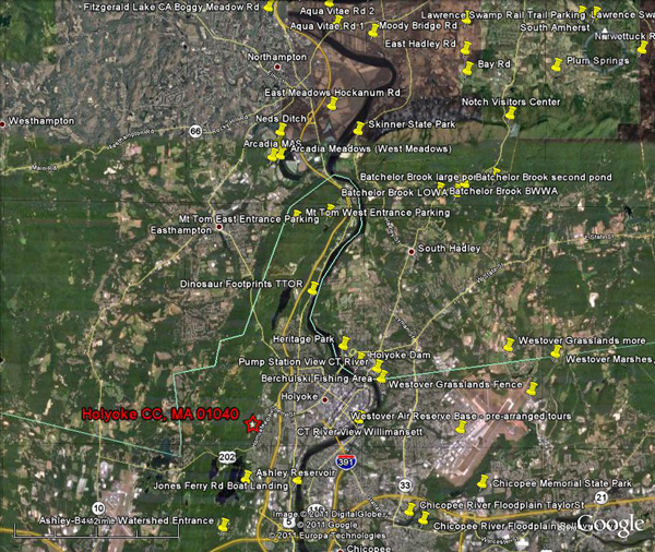
Turn
south (right) from the HCC entrance on Homestead Ave and go one mile to the
second light. Turn right up short hill
on Lower Westfield Road. Go straight a short way until you come to a gate and
park on right before the no parking signs. Walk in and bird along the road and
in the woods to left near smaller ponds and right along the large pond.
Continue along the road as long as you have time and return. If you follow the
road around the large pond, turning right before you come to another parking
lot, you will pass another gate and the Elks Club to Lower Westfield Road,
where you turn right and walk a short way to the parking place.
Mt Tom
and Arcadia Take Rte
91 north and a mile down get off on Rte 141 toward Easthampton (second off-ramp
of exit 17). Follow Rte 141 west to the crest of the mountain and turn into the
entrance to Mt Tom State Park. If it is open follow it along the ridge,
stopping to bird until you come to the headquarters, where you can turn left
and go short way to Bray Tower. You can continue along the ridge if the gate is
open, parking at a lot where a walking trail climbs steeply up to Goats Peak
and the tower there. Otherwise turn right and go down the mountain to Route 5,
stopping to bird as you go. If the Rte 141 entrance to Mt Tom is closed, park
and walk in the entrance road or/then continue west down the mountain on Rte
141 into Easthampton. Take the
first right on East St. and go 2 miles and take a left on Fort Hill Road, where
there is a sign to Mass Audubon’s Arcadia
Sanctuary. Take a right and quick left into Arcadia, where you can park
and bird the Sanctuary, not missing the marsh overlook. You can bird along Fort
Hill Road and the road to the right (Old Springfield) going beyond the entrance
to the Sanctuary, which comes to a bridge that is usually closed this time of
year, but gives views of the Oxbow pond. If you have time park and walk across
the bridge into the Arcadia (West) Meadows, turning left and along a hedge to
areas with more fields and thickets, then walk to your right to the Great Blue
Heron colony in Ned’s Ditch, following the edge of the field and the road back
to Bridge. Return
to East St and turn left, going 1 mile and turning right on Rte 5 for 3 miles
to take a right into the main entrance to Mt Tom. If the gate is open the road
will take you to the top of the ridge and explore as above.
East
Meadows, Northampton Return
down the mountain to Rte 5 and turn right to return to Rte 91 south and HCC, or
turn left and go 3+ miles into Northampton.
Pass the entrance to Rte 91 and turn right on Hockanum
Road, keep right on Hockanum after going under RR
bridge and go over Rte 91 to meadows area. Follow road as far as the muddy road
conditions allow and scan to south and east. A large rain pool to east can hold
huge numbers of waterfowl. If conditions
allow take the first or second road to left into the meadows, but be extremely
cautious and turn around if you come to very muddy areas. If the
roads are too bad, cross back over Rte 91 and take the first right on Henry
Street, bearing left over the dike. After the road turns sharp left take the
right on Cross Path Road and at the end turn right under Rte 91 to the Airport
area. Going straight will take you along the south side of the runway, but
quickly can become treacherous in the spring, so get out and scan. Turn around and turn right before going out
under Rte 91 and follow the road to the river, turning right to go down along
the north side of the runway, also eventually often impassable. Turn around and
return to intersedtion, this time going straight
along Rte 91, then curving left past some houses until you get to a red barn.
Bird the thickets here and and along the way,
scanning the fields. Turn around if the road is bad beyond this point.
Hadley
Meadows Return
under Rte 91 and go straight out the road (Ferry Hill) to Rte 5 and take a
right, going thru the light and over the bridge into Hadley. (You can get on Rte 91 south here-see below.)
As soon as you cross the bridge and before lights take an obscure right on Aqua
Vita Road, which brings you past some houses on the riverbank and then into the
open fields and a rain pool. At the end take a right on Bay Road (Rte 147) and
then take the next right on Middle St, which is a dead end leading to a treed
overlook into Hadley Cove. Go back
to Bay Rd. and if you want to take a short loop through Hadley turn left, then
the next right on West Street. Go across route 9 and continue on West, until
your first left on Cemetery Road. Follow
this through the “Honeypot” meadows over the dike and
to where the town road ends at the edge of the river. Return and take a right
at the dike back to Rte 9, where you turn right and go over the bridge, turning
south on Rte 91. A long
loop through Hadley is available by turning right off Middle
onto Bay Road. A half mile down take a right off Rte
47 to continue on Bay Road. Go almost a mile and take an easy left on East
Hadley Road, watching for raptors and field birds here (Snipe in wet area).
Take a left on South Maple at the end and follow it through more fields. Cross Route 9 at the shopping malls and then go through the next
light and stop to check the fields around the Hadley Horse Farm.
Continue straight though as the road name changes to Roosevelt, then Meadow,
going into a corner of Amherst where there are more meadows on the left. Take a
left on Russellville Road and follow it to Rte 47, taking a left. Follow this four miles until you pass Rocky Hill Road and a school
on the left. Turn right on North Lane and stop at a small lot on right to climb
dike and survey river. Continue on curving right onto
West Road then right on Cemetery into the Honeypot as
above.
Holyoke
Dam If
returning south on Rte 91 from Northampton take exit 17 east on Rte 141 (one
way), going straight through lights across Rte 5 and 1 mile down after another
set of lights take School Street to left a short way then right on Rte 202 and
follow as below. If leaving Mt Tom at the main entrance, take a right on Rte 5,
go 1+ miles and take a left at Rte 202 on Lincoln St. Follow this road across
river and go around the first rotary to last exit onto Main St, then immediate
left on Summit St. Go straight to edge of river and survey pool behind dam from
small parking lot with lookout (Heritage Park). Continue down road that becomes
Canal St. and watch for parking lot on right that overlooks dam itself. Down hill a little farther pull in at auto repair shop
parking lot on right that leads to an entrance to a park under construction
below dam. Walk in to survey below the dam.
Retrace your steps back to Rt 202 rotary and
follow signs across bridge and through Holyoke to Rte 91 south to the HCC exit
16. |
|